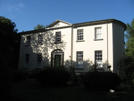
Ballynagar
Ballynagar in Irish “Béal Átha na gCarr” meaning “mouth of the ford of the cars” according to John O’Donovan is 108.59 acres or 43.95 hectares in size and is in the Electoral division of Ballynagar. The local spelling of the townland is Ballinagar.
Ballynagar borders Ballyglass, Coarseparks, Cuilleendaeagh, Garraunphaudeen and Gortnakilla.
What we recorded
- Placenames
- 3
- 3 field
- Houses
- 2
- Buildings
- 1
By type
Map
Placenames
| Name | Type | Notes |
|---|---|---|
| Hasty’s Field | field | |
| The Horsepark | field | |
| The Bull Field | field |
Houses
| Name | Notes |
|---|---|
| Goonan’s House | There was a few houses in this building. |
| Ballynagar House |
Buildings
| Name | Notes |
|---|---|
| Harness House |
Population
In the 1841 census there were 10 people and 1 house in the townland and in the 1851 census there were 5 people and 1 house. The 1840 map showed 1 house and 2 outbuildings. The 1847-64 Griffith’s Valuation had 1 house and 1 landholder. In the 1901 census there was 1 house and 10 inhabitants and in the 1911 census 1 house and 7 inhabitants.
Land and Household Records
Landholders and heads of household recorded in the Tithe Applotment Books, Griffith’s Valuation, and the 1901, 1911 and 1926 censuses.
Tithe Applotment Books, 1834
Not yet compiled.
Griffith’s Valuation, 1856
Not yet compiled.
1901 census
Not yet compiled.
1911 census
Not yet compiled.
1926 census
- John Aylward Lewis
About the Townland
The townland is renowned for containing the substantial home of the Aylward/Lewis families who were large landowners in the area. The house is still habitable today but not occupied, it is listed on the National Inventory of Architectural Heritage. There is a ringfort recorded in the east end of the townland.